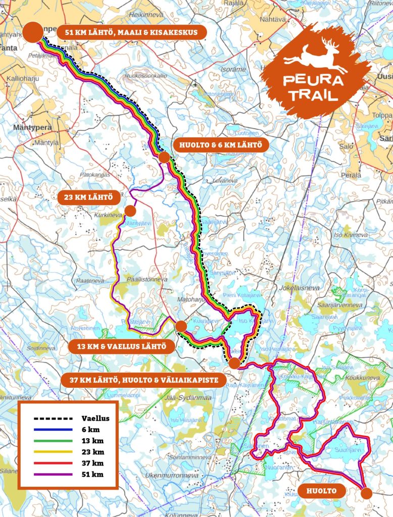
There's a route for everyone
In the event, you can choose from four routes of different lengths (total vertical meters in parentheses):
6 km Nice Musta (40 m)
13 km Interesting Kirvesheikki (104 m)
22 km Preposterous Poskeinen (179 m)
37 km Wild Harjuntakanen (347 m)
There is transportation from the race center to the departures, and the finish of all routes is at the race center. Read the route descriptions below and choose which challenges you will take on!
6 km – Nice Musta
The beginning of the route follows the shore of the scenic Musta lake. In the beginning, you can enjoy the smooth long trees. After the black log cabin, the journey hastily turns along the meandering needle path.
You will pass the devil's field characteristic of Eteläsydänmaa before arriving at Petäjämäki's outdoor recreation area. After a short biting track transition, you can still enjoy the scenery of Korkeakallio before descending to the finish area.
The route is easy to navigate and is also suitable for walking or for younger participants.
As a partner on the way:
13 km – Interesting Kirvesheikki
Departure takes place from Kuivajärvi rental house. There is a beautiful view of the lake from the path that follows the beach.
The route runs from the stand between the two lakes over the Kirves-Heikki canal before turning north.
You bypass the lull. In the rolling terrain, you pass Särysjärvi, Ahveroinen and Saarijärvi.
You will enjoy the pine trees for a while on the shore of the beautiful lake called Musta. After the black log cabin, the journey hastily turns along winding needle paths.
The route is easy to navigate and is well suited as a first trail running challenge.
Service points
7 km: water, sports drink, rieska, pickles, raisins
As a partner on the way:
22 km – Preposterous Poskeinen
You can start your journey from the historic Mäntyjärvi log cabin. The path continues to Rapakkolammi, where you wade for a while in a knee-high swamp.
Before arriving at Raatejärvi's rental trail, you will encounter several challenging rocks where you can place your feet precisely.
At some point you feel like sitting on the long trees on Koukkunen beach to admire perhaps the most beautiful view of the route. However, you continue your journey to Kuivajärvi, which is preceded by a rockier trail section and a short road transition.
For the rest of the journey, the route merges with the 13 km route, except for the additional run in Poskeinen. The ridges offer great views over the lake.
The route is suitable for you who want a slightly longer challenge and pleasure. You can get through the rocky part of the beginning, as long as you keep your composure along the way.
Service points
8 km: water, sports drink, rieska, pickles, raisins
16 km: water, sports drink, rieska, pickles, raisins
As a partner on the way:
37 km – Wild Harjuntakanen
The departure takes place from the historic Mäntyjärvi log cabin. The start to Poskeinen is the same as the 22 km route. There the route diverges from Peuranpolu.
The transition to the Suurijävi hiking trail is varied both in terms of scenery and terrain. If you are in the mood for camping in traffic, you should deviate from the route to Imarrekiv. The huge shifting boulders on the edge of the pirunpelto are an impressive sight.
After Imarrekivi, you will enjoy the wider bottom of the old forest road for a while. At the southernmost point of the route, there is a short road transition, after which you pass the new Suurijärvi desert hut.
On the way back to Peuranpolku, the route takes a slightly stonier, less traveled path. The route returns to Poskeinen, where it joins the 22 km route.
The route is suitable for you who want to get the most out of yourself and the wonderful routes. The journey is as demanding as a marathon.
Service points
7 km: water, sports drink, rieska, pickles, raisins
15 km: water, sports drink, rieska, pickles, raisins
23 km: water, sports drink, rieska, pickles, raisins
31 km: water, sports drink, rieska, pickles, raisins